hiking the belledonne GR738

Gr©738, crossing the belledonne in the footsteps of the shepherds.

Sylvain takes you on the GR©738 in the Belledonne range, a mix of rocky landscapes and green mountain pastures!

The GR©738 crosses the Belledonne chain, a ridge line culminating at nearly 3000 metres, dominating Grenoble and its valley. These 140 kilometres still have 10 000 metres of ascent and let you discover summits, lakes and panoramas on paths once used only by shepherds.

Some information on this trek in the belledonne range:

  • trek duration in the Queyras

    Duration

    11 days

  • hiking distance in the Queyras

    Distance

    122 kilometres
    Between 5 and 8 hours of walking per day

  • hike elevation gain in the Queyras

    Elevation gain

    Between 450 and 1300 metres of height gained per stage.
    Highest point: Col de la Vache (2556 m)

  • trek for beginners in the queyras

    Difficulty

    Advanced level

  • where to sleep in the queyras

    Autonomy

    Semi-complete:
    route from hut to hut, with an unmanned hut on the route

  • queyras climate

    Best time of year for this trek

    Between June and September
    note the snow cover and opening of the huts).

Sylvain’s route
on the gr©738

(Trek completed in august 2018)

1. From Aiguebelle to Yayla de Rochebrune's yurts: 14 km, 6 hr 30, 1245 m + / 685 m -
2. From the Yayla de Rochebrune yurts to the Perrière hut: 16 km, 8 hr, 1805 m + / 825 m - 3.
From the Perrière hut to the Pierre du Carre hut: 13 km, 7 hr, 1220 m + / 1320 m - 4.
From the Pierre du Carre hut to the Gîte de l'Alpage de l'Oule: 16 km, 7 hr, 1280 m + / 1200 m - 5.
From the Gîte de l'Alpage de l'Oule to the Gîte de la Martinette: 11 km, 6 hr, 700 m + / 1300 m -
6. From the Gîte de la Martinette to the 7 Laux hut: 9 km, 5 hr, 1100 m + / 100 m -
7. From the 7 Laux hut to Habert d'Aiguebelle: 10 km, 5 hr, 540 m + / 900 m -
8. From Habert d'Aiguebelle to the Jean Collet hut: 8.5 km, 6 hr, 1060 m + / 875 m -
9. From the Jean Collet hut to the La Pra hut: 7 km, 4 hr 30, 950 m + / 780 m. From La Pra to Chamrousse (Le Recoin): 8.5 km, 3 hr, 15 475 m + / 915 m -
11. From Chamrousse to Vizille: 17 km, 5 hr 30, 410 m + / 1785 m -

From allevard to the perrière hut, our first steps in savoie.

We start from Allevard, a small town in Savoie at the foot of the massif.
Our first day is in the forest. Nevertheless, the backdrop is already impressive and the slope steep. This start to the journey reminds us of the region's mining past: we pass several old iron mines, going up towards the crest of Mollard. Ore had been mined there since the Middle Ages. Under a hot sun, we head down towards our first accommodation: the yurts of Yayla will leave us with some fond memories. First, because sleeping in a yurt is an experience that we wouldn't necessarily have expected here, and secondly because we meet a group of hikers there with whom we’ll share every evening of this hike. It’s through chance encounters along the way that great friendships are born.

The next day, the first grandiose panoramas await us, on a beautiful stretch alternating between forest and mountain pastures. On the ridge line which follows the Col du Champet, Mont-Blanc comes into view, standing tall in front of our eyes. Further on, the springs of Gargoton offer us a refreshing break.The small hut of La Perrière, bordered by green mountain pasture, isn’t manned. Tonight, we prepare our freeze-dried dishes and heat up our mess tins. The cards come out and the evening is a very friendly affair.

Hiking in Belledonne - Gargoton

La perrière - l'oule:
to the heart of the matter!

After these two approach days mixing forests and ridges, here we are at the heart of the matter.
The mountain of Belledonne welcomes us with all its majesty. The mountain pastures near the Perrière hut are gentle and full of flowers, but ahead of us, giant rocks rise skyward.The sky is dark this morning. We leave very early in the company of our new walking friends. A storm is forecast for 11.00am, but seems to want to get going early.
From our first steps, it rumbles and lightning tears through the sky. The threat draws closer and the raindrops fall. Despite the superb spectacle of peaks and ridges bathed in surreal light, we press on. After cresting the Col de la Frêche then the Col d’Arpingon, the sky grows less angry.
The panoramas over Mont-Blanc, the Grands Moulins and La Lauzière will have to wait for another time, but we enjoy the rest of the stage. A long descent awaits us to the torrent of Bens. We cross it and thus leave Savoie for Isère.
Then, a nice ascent awaits us, under the returning sun, through the beautiful alpine pasture of Claran. I’ve never seen so many blueberries, which invite us to stop again and again. But the clouds are fickle, and we finally arrive just in time at the small Pierre du Carre hut, nestled between forest and mountain pastures. A warm evening with friends, in the shelter, awaits us.

The big cat that lives in the Pierre du Carre hut understandably stays in the shelter in the morning. No luck, it's still raining. But the morning rain doesn’t stop the brave hiker on the GR©738. The movement of clouds in the trees and on the meadows gives a mysterious, romantic aspect to this start of the stage.
The Aup Bernard hut, planted in the middle of the pasture, provides us with a wonderful picnic area. Further down, we return to civilisation for a moment, passing the village of Gleyzin.
A splendid ascent awaits us: along the stream, a flock of sheep are having a fine old time. They almost seem to encourage us up this steep slope.
A few more steps on increasingly rocky terrain and here, perched high up, is the sheepfold and the Alpage de l'Oule hut. On arrival, the clouds kindly open up a little to allow us to admire the panorama. A little later, at nightfall, the spectacle of lights, down there in the valley, proves just as beautiful.

GR738 hike - la perrière

From oule to fond de france:
blueberries and rhododendrons

We head up through a beautiful mountain pasture landscape, sown with blueberries and rhododendrons, towards the cross and lake of Léat.The little chalet by the lake is so cute.It invites us for a first break before setting out again into the mountain pastures.
Surrounded by peaks, today we’re walking on relatively easy ground, if it wasn’t for the height difference, in a most hospitable area. The streams flow, the grass is green. A picnic is called for at the Petite-Valloire chalet. We’re joined here by our jolly band of friends. Ségolène, the newcomer, saw the sole of her boot come off completely during the first hour of walking! She’ll have quite a problem in the long, steep descent that follows, through the woods, to reach Fond de France.
Tonight, we’re enjoying the comfort of the Gîte de la Martinette: we’re back down in the valley, a very peaceful valley because it’s hidden in Belledonne, where the Bréda and Pleynet flow. The sun’s back, and drinks this evening will be taken on the terrace!

belledonne trek, gr738

Fond de france - habert d’aiguebelle:
the lakes of sept laux.

It’s a long climb that awaits us tomorrow! We set off, rested, from Martinette. To start with, a bucolic forest welcomes our steps.
After a small detour, we admire the Pissou waterfall, which gushes away nicely. The slope then becomes steeper to lead us back in a few kilometres to the mountain pastures. We follow the course of the streams.
The landscape becomes more and more rocky as we climb. The 2000 metres altitude threshold is crossed, but there’s more to come before we reach the first lake. After the square lake, the spectacle is impressive:it’s a succession of water and rocks, topped by impressive peaks. A heck of a backdrop against which to enjoy another wonderful evening with friends!
The procession of lakes and rocks continues for our 5th day of walking. A world of water and stones. The winter ice is almost gone. A wonderful flock, and a few good-natured guard dogs watching over them, also liven up our morning, posted around the cabin at the end of the lakes.
The tough Col de la Vache awaits us: the climb is gradual and we keep stopping to admire the landscape below. But the effort is sustained and the slope very steep. The path has given way to scree. The reward of the panorama, on both sides of the pass, of the jagged summits dominating the valleys, is most impressive.
The descent requires caution: a maze of stones, where each step is carefully chosen. We mustn’t lose sight of the general direction, either.
We finally find the path, a beautiful balcony that leads us to Pas de la Coche. The sky has darkened, the rain comes down faster than a galloping hiker.
We’re not slow to descend to the welcoming Habert d'Aiguebelle hut, which has been recently renovated.

Habert d'aiguebelle - vizille:
a final lake among the panoramas!

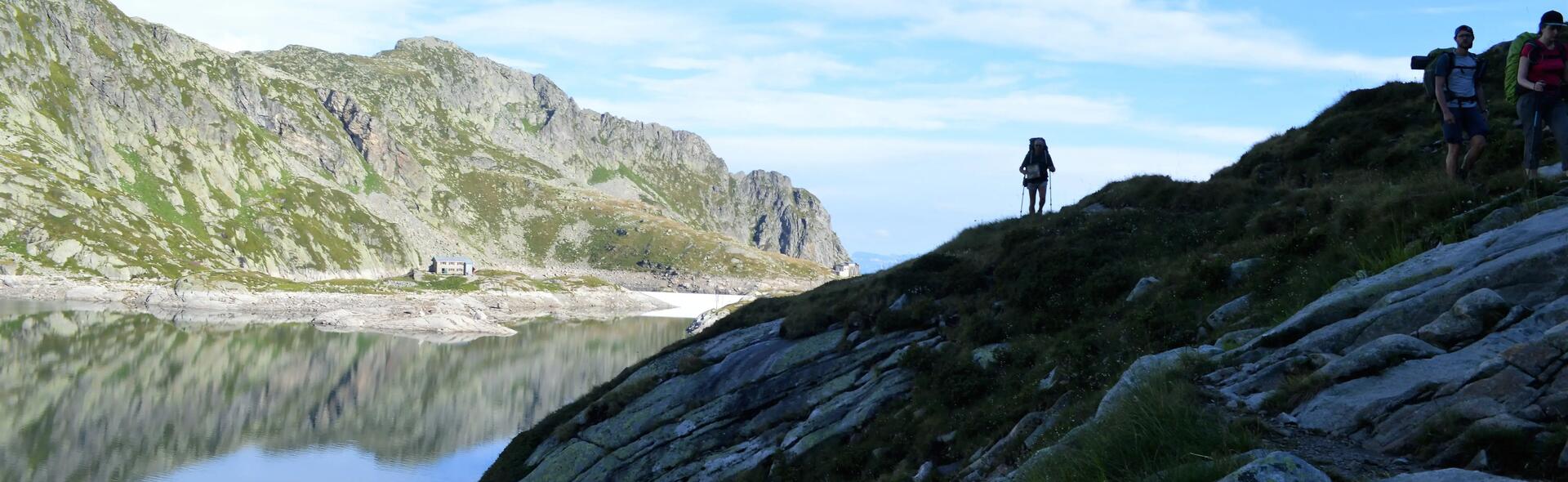
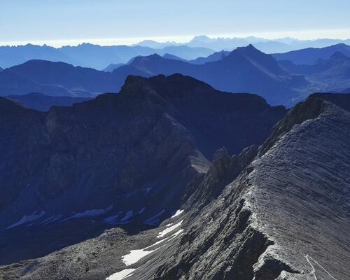
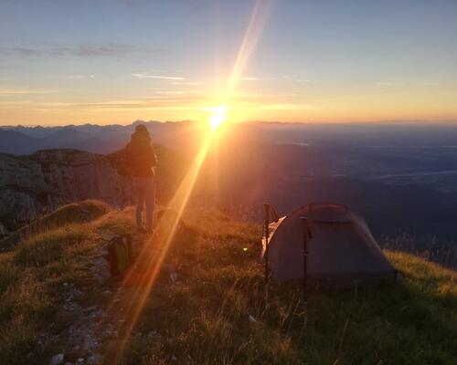
The next day, we cross the passage of the Brèche de Roche Fendu, a particularly wild and rocky place, a little austere too, which retains traces of its mining past: a little further on, the Col de la Mine de Fer (Iron Mine Pass) is aptly named and the entrance to the excavation is still visible. But it’s the beautiful views over the Oisans first, then at the pass overlooking the lakes of Sept-Laux, which we admire one last time from above, that truly delight us. The descent to the Jean Collet hut, through rocks and mountain pastures, is fairly quick. We arrive quite early and take it in our stride: the rain, which has largely held off in recent days, returns soon after. A beautiful clear spell after dinner lets us admire the evening lights and magical view of the Grésivaudan, the city of Grenoble below and the Chartreuse opposite.
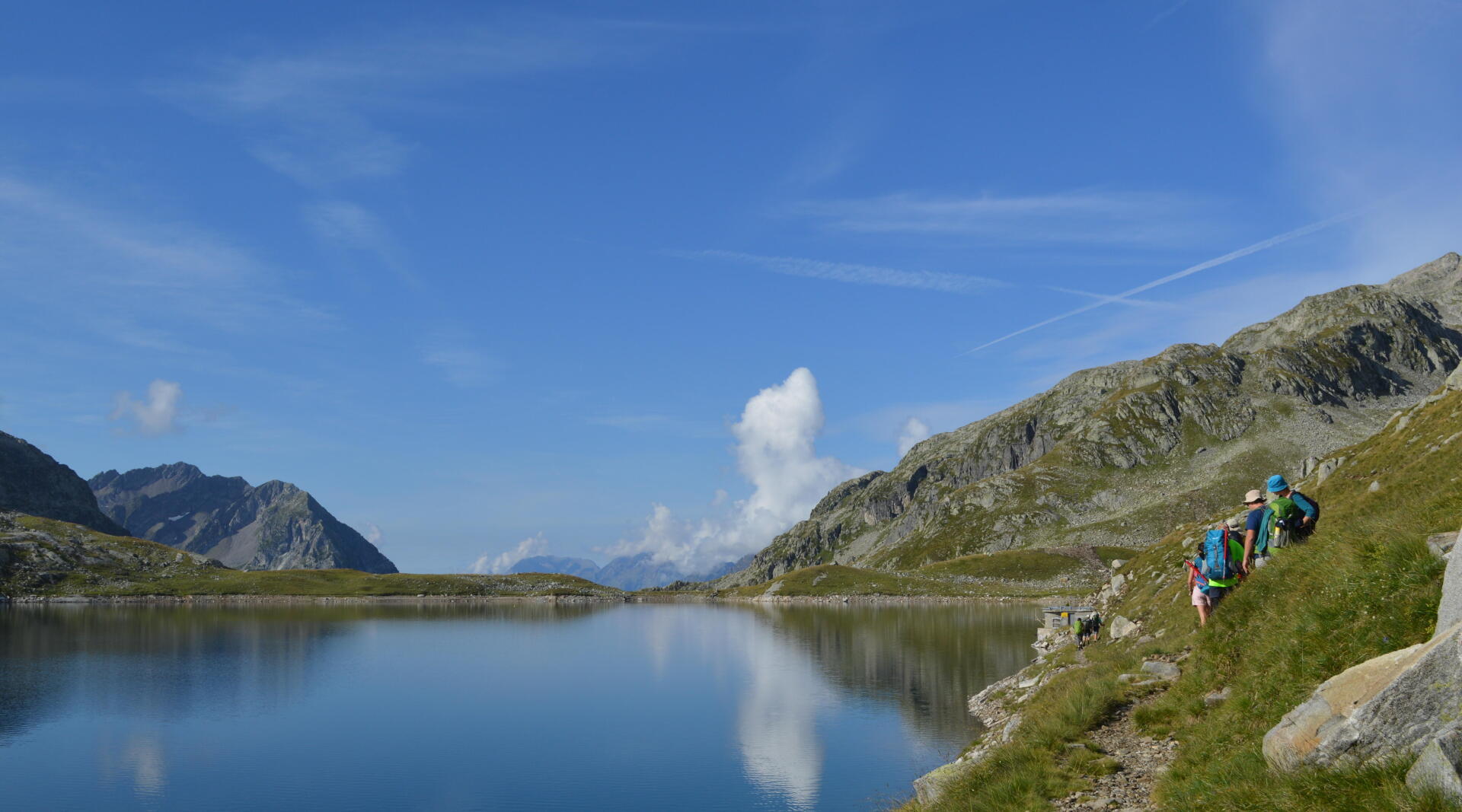
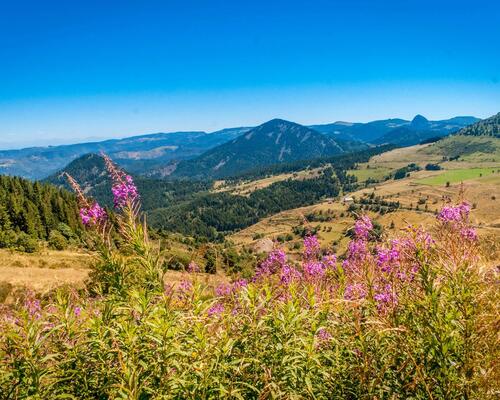
In the soft morning light, we leave the Jean Collet hut to enjoy the mountains one last time. A beautiful balcony path along alpine meadows, bypassing the Grande Lance de Domène, then, after Col de la Sitre and Col du Loup, in front of the Chartreuse, we reach Lac du Crozet.
We then head up to the La Pra hut and its pretty valley. The sunny terrace is perfect for lunch.

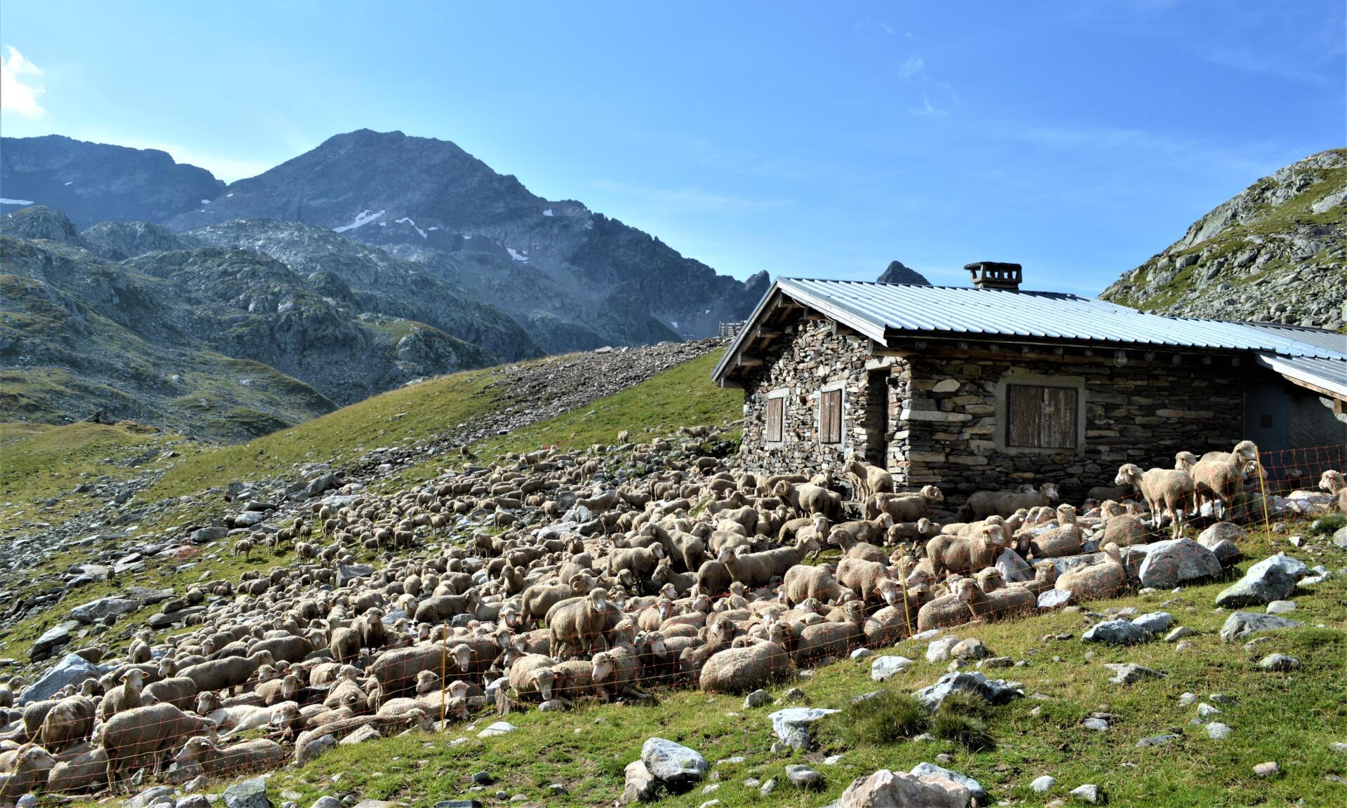
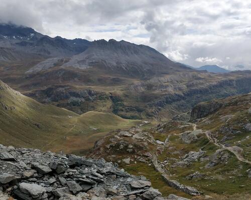
A good afternoon’s walking still awaits us under a sun again at its zenith: we cross some good scree, then streams where it’s good to dip in your hat to cool off.We also meet a huge flock of sheep and goats, which climb with us on a rocky slope. We chat with the shepherd, sat on a rock, quietly watching his 1500-strong flock. He loves his job, because he loves the mountains, but the difficulties are growing: new health standards have forced him to give up his cheese, which is too restrictive. The wolf is another consideration: at night, you have to pen the animals, keep watch. But it's natural for it to come back.
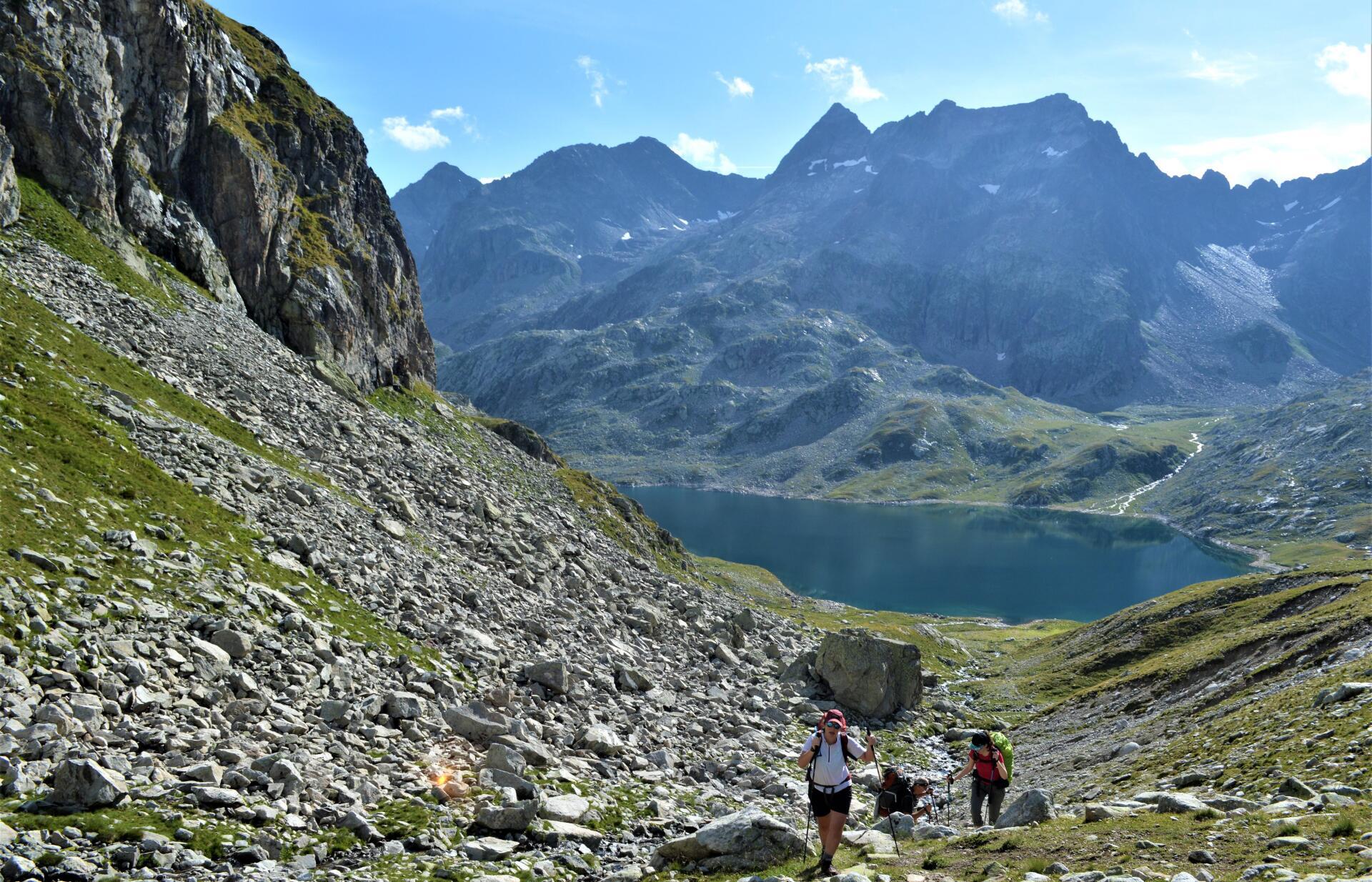
We go down to the Robert Lakes. We admire the reflection of the peaks in their clear waters, before leaving for a final push towards Chamrousse. Over the final kilometres, we find the facilities of the ski resort. Our return to civilisation begins. Tonight, we sleep in Chamrousse, in a small hotel, and have dinner at the restaurant. There aren’t many people.
The last day on the trail is upon us. These ten days have been packed and have gone by so quickly. A long forest descent, which gives a glimpse of beautiful panoramas over the Vercors and passes through a few hamlets, propels us towards Vizille. The descent is steep, on a sometimes stony path, but these last 17 kilometres are quickly swallowed up: at midday, we’re at the entrance to the park of Château de Vizille. It’s here, in a place which marked the history of the French revolution (the Estates General of Dauphiné, which influenced the revolution, was held there in 1788), that our journey on the GR©738 ends.

As a bonus...

3 DAYS OF TREKKING IN THE QUEYRAS NATURE RESERVE

Fauna observed

We come across all the inhabitants of the mountains on the GR©738: jackdaw, marmots of course, as well as majestic ibex, like the one who seemed to be waiting for us at Col de la Vache. Of course, herds of sheep are part of the backdrop.

My sustainable development tip

Remember to take two or three rubbish bags with you: you can get rid of waste on three or four sections of the route, no more.

Top tips for this trek

You should consider setting off with something to eat for the day on the second stage, because the unmanned La Perrière hut doesn’t let you restock!

TREKING IN THE Belledonne massif by Sylvain Bazin

Trek experienced and described by sylvain

Journalist and author specialising in hiking and active tourism, a great hiker and nature lover.

Check out this route and lots of other ideas for trekking in the Alpine arc in my book: Alpes, les plus beaux treks (Alps, the very best treks - Editions Glénat).

More tips and testimonials

Two-day Trek in the Mercantour National Park

Two-day Trek in the Mercantour National Park

Advice for those who want to scale the heights: Jean-Louis shares his trekking experience with his Mont Pelat climb and amazing view over the Mercantour National Park! A route shared with the marmots, antelopes and a good group of friends.

Top 5 hiking routes in Auvergne-Rhône-Alpes

Top 5 walking travel routes in Auvergne-Rhône-Alpes

Discover our best walking travel routes in Auvergne-Rhône-Alpes. Discoveries, thrills and great encounters guaranteed!

trekking route in the vanoise

At the heart of the Vanoise mountain range, trekking around the glaciers

This year, what if were to choose France as the place to make the most of the end of the season? A week of trekking, all alone in the world, in the heart of the Vanoise national park. It's unspoilt, it's natural, it's magnificent. In short, it's the perfect spot!

TREKKING RECIPE: velvety mushroom soup

TREKKING RECIPE: velvety mushroom soup

An easy-to-prepare dehydrated recipe for food lovers going on a bivouac!

Trekking in Italy

Trekking in Italy

Do you dream of touring Italy on foot? Check out our selection of the best hiking or trekking destinations in Italy!

An easy recipe for trekking

COOKING ON A TREK: THE CHOCOLATE CREAM

A delicious trekking recipe to carry in your backpack for a yummy bivouac experience!